I rented a Cessna 182 from My Flight Corp. (based at Galebert Airport) in Panama City, Panama, and flew (as second in command) for about 1.5 hours over various parts of central Panama, including its southern and northern coast, the Gatun, Pedro Miguel and Miraflores Locks, the city of Colon, the former Rodman, Howard, and Fort Gulick military bases and Taboga Island. The weather was fairly clear except for some low clouds and precipitation over Colon. Most of all it was an enjoyable way to see all the sites from above after I'd spent plenty of time researching the same sites on the ground.
Above: My rental Cessna 182.
Above: My flight path over central Panama (dotted line).
Above: Taking off from Runway 36 at Galebert Airport.
 Above: During taking off you can see Albrook Mall (foreground) and the skyline of Panama City.
 Above: Clearing a hill shortly after takeoff.
 Above: Aerial view of the grounds of the new U.S. Embassy (right) in the Clayton district of Panama City.
 Above: A glimpse of the Miraflores Locks to the west.
 Above: Flying past the Estadio Nacional Rodney Carew, Panama City's main baseball stadium, built in 1999.
  Above: A hazy distant waterfront skyline of Panama City, the new Panama-Colon highway (left) and the Avenida de La Paz (right).
  Above: East view of the Ramonazo and San Isidro neighborhoods just south of Las Cumbres, and north of Panama City.
  Above: The Maria Henriques neighborhood, just north of Las Cumbres, and the Boyd Roosevelt highway (Carretera Transitmica).
 Above: Construction of the new highway from Panama City to Colon is underway and upon completion will substantially reduce the travel time between the cities (which is now over two hours on very bad roads).
  Above and below: The town of Calzada Larga, its airport (center) and a large cement factory (right).
  Above: Another view of the airport and town of Calzada Larga.
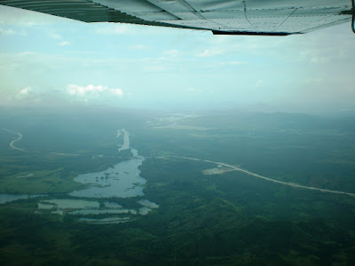
 Above: Lago Alajuela in the distance.
  Above: There was some precipitation and dense clouds just north of Calzada Larga.
 Above: Lago Alajuela (foreground) provides fresh water through the Madden Dam (center) and into the Panama Canal.
  Above: Lago Alajuela (foreground) provides fresh water through the Madden Dam (top), which then feeds into the Panama Canal a few miles west of the dam.
  Above and below: The new highway and Madden Dam.

Above: The northern part of the small town of Gatuncillo (in the Urbanizacion Quebrada Ancha), west of Lago Alajuela.
 Above: The green hills northwest of Lago Alajuela.
 Above and below: Neighborhood of Sabanita, 6km east of Colón.
  Above: The outer flow of Lake Gatun just south of Sabanita.
  Above: Fuel tank farm at Punta Payardi, 8km east of Colón.
 Above: Tank farm at Punta Payardi and power plant (foreground).
 Above: Approaching Colón from the east.
 Above: Huge merchandise depots across from Colón’s Zona Libre.
 Above: Huge merchandise depots across from Colón’s Zona Libre.
  Above: The former Fort Gulick military base 3km southeast of Colón (photo taken from abou 2800 feet).
 Above: The former Fort Gulick military base and the infamous School of the Americas.
 Above and below: The former Fort Gulick military base and the infamous School of the Americas (large buidling), which is now the Melia Panama Canal hotel.
 Above: The former Fort Gulick base facilities and housing.
 Above and below: The former Fort Gulick base facilities and housing, much of which has now become an upper-middle class residential area.
 Above: Underground fuel tanks 1km southwest of the former Fort Gulick.
 Above: Approaching the Gatun Locks from the northeast.
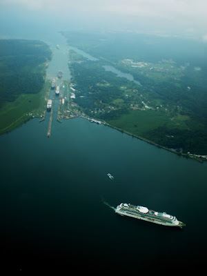
 Above and below: The Gatun Locks viewed from the southeast. These locks form a triple-flight lock system that raises and lowers vessels a total of 85 feet.
 Above: A cruise ship leaves the Gatun Locks while another cruise ship and two cargo ships are still maneuvering through the locks.
  Above: View of the Gatun Locks, Gatun Dam, Guarapo Island (left), a cruise ship entering Gatun Lake, and Limon Bay (top) (picture taken from 3200 feet).
 Above: The cruise ship is heading south into the Gatun Lake.
  Above: Three container ships and a cruise ship navigate through the Gatun Locks.
 Above and below: The Gatun Dam, which controls the waterflow from Lake Gatun into the Rio Chagres.
  Above: Pilot in command turning southwest over Lake Gatun, with Trinidad Island and Trinidad Chiouita Island visible in the distance.
  Above and below: Container vessels in Lake Gatun awaiting their turn to cross the Gatun Locks.
 Above: Flying past Cape Mala and the waterfront village of La Treinticinco (background).
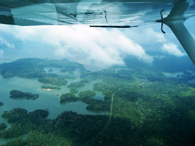
 Above: Trinidad Bay in Lake Gatun and Pelican Island (center).
 Above: Flying past Cano Lagertera near the village of Las Pavas.
 Above: Flying over the village of Gigante on the edge of Cano Gigante.
 Above: The area is filled with swamps and tropical vegetation.
 Above: The area around Larga Island (top left).
 Above: Flying past Cano Quebrado Point (bottom) and Barbacoas Island (right) as the Tabernilla Reach turns (center) into the San Pablo Reach (bottom right) of the canal.
 Above: Flying parallel to the San Pablo Reach of the canal, past Bondad Point and toward the tiny islands of Vigia, Potra, Dos Barros, Toro, Congo and Macho (center), just west of Gamboa.
 Above: Just south of the San Pablo Reach of the canal is Maginque Island (foreground) and mouth of the Rio Bailamonos (background).
 Above: The Panama Canal Railroad line and its passage over the mouth of the Rio Frijoles (far right).
 Above: Juan Grande Point (foreground) and Gargona Island (top center), and in the distance the port of Gamboa.
 Above: Passing Juan Grande Point.
 Above: The Panama Canal Railroad line approaching Gamboa.
  Above: The port at Gamboa facing the canal and Santa Cruz Island (right, which is now partially connected to land).
 Above: The port at Gamboa and the north end of the canal's Gaillard Cut (left).
 Above: The port at Gamboa.
 Above: Rail and vehicle bridge over the Rio Charges connecting Gamboa with south-central Panama.
 Above: The north end of the Gaillard Cut (or Culebra Cut), which is one of the narrowest sections of the Panama Canal, and a penitentiary (bottom left; formerly the U.S. military prison for the canal zone).
 Above: The dipper dredger Rialto Christensen (center), one of the world’s largest, and a barge sit dredging at the north end of the Gaillard Cut of the Panama Canal.
 Above: Another view of the Gaillard Cut and the dipper dredger Rialto Christensen (left).
 Above: A container ship heads north along a section of the Gaillard Cut that is being widened by excavation and explosives.
 Above: Contractor Hill (top) along the Gaillard Cut. Extensive dredging and excavations are underway to enlarge this section of the canal.
 Above: Contractor Hill along the Gaillard Cut. An old radar tower sits idle nearby (bottom right).
 Above and below: Gold Hill (left) and Contractor Hill (center) along the Gaillard Cut.
 Above and below: A container ship heading north under the Puente Centernario (Centennial Bridge), a 6-lane cable-stayed 3450-foot bridge built at the continental divide, thus connecting North and South America.
 Above: The Puente Centenario and the Gaillard Cut of the Panama Canal looking west.
 Above and below: The elegant, modern Puente Centernario.
 Above and below: A container vessel enters the Pedro Miguel Locks, which forms a single-flight lock system between Lake Gatun and Miraflores Lake. The ship will be raised approximately 30 feet.
 Above and below: The Pedro Miguel Locks, which forms a single-flight lock system between Lake Gatun and Miraflores Lake.
 Above: The expansion of canal facilities and enlargement of the canal itself has already begun, with some of the work visible in this picture (top right).
 Above and below: View of Pedro Miguel Locks from the southeast.
 Above and below: Flying south of the Pedro Miguel Locks over Lake Miraflores, which leads to the Miraflores Locks.
 Above and 3 pictures below: The Miraflores Locks, a two-tiered system of locks.


 Above: The retracted swing bridge over the southern end of the Miraflores Locks.


1 comment:
Awesome shots Andre! I felt like I was in the plane and part of the adventure. Cheers - Sean
Post a Comment